
Trace an Arvada Street Directory
A useful by-address search is a chain of checks. Start with the normalized street address in the Jefferson County Property Records Search. Save the property address, city, postal code, PIN, AIN, TAG, owner, property class, and mailing address that appear in the result grid. Then use the parcel identity, not a guessed household name, to move between systems.
- Enter the house number, direction, street name, street type, unit, city, and ZIP. If the result is empty, test direction and street-type variants before changing the county.
- Open the same parcel in jMap. Confirm the polygon, city or county boundary, subdivision, and nearby layers, then save the PIN or AIN from the popup.
- For one known person, use Colorado’s individual voter match with first name, last name, ZIP, and birthday. Treat a non-match as a prompt to check a prior ZIP or protected status, not as proof of absence.
- Use the assessor’s sale-history document number in the recorder index. Read grantor, grantee, recording date, reception number, instrument type, and legal description before following the prior owner.
- Ask the library or historical collections about older telephone, reverse, or criss-cross volumes. Those sources can place a listed subscriber at an earlier address, but the exact Arvada reverse run was not verified.
The order matters. An owner field is not an occupant field, and a voter match is not a block-wide roll. The address, parcel, and legal description give each later search a stable anchor.
Arvada Street Search Fields
The Jefferson assessor address form is more exact than a loose street-name search. Street type is required in the address query, and city and postal code act as important constraints. The county list includes Arvada and other Jefferson-area cities, so a result is a county-portal match rather than a declaration of city limits.
| Field | Type | Required | Options or placeholder |
|---|---|---|---|
| Address Number | text | Not individually; one query field is needed | eg: 12345 |
| Pre-directional Type | dropdown | No | E, N, NW, S, SE, SW, W |
| Street Name | text | No | eg: Main |
| Street Type | dropdown | Yes in address query | ALY, AVE, BLF, BLVD, BYP, CIR, CT, CTR, DR, HWY, LN, LOOP, MTN, PASS, PKWY, PKY, PL, PLACE, RD, RDG, ST, TER, TERR, TR, TRL, WALK, WAY |
| Unit Number | text | No | eg: 10 |
| City | dropdown | Yes in address query | ARVADA plus other Jefferson-area cities |
| Postal Code | dropdown | Yes in address query | Arvada values shown: 80001, 80002, 80003, 80004, 80005, 80007 |
| Search | button | Not applicable | Results grid |
The result grid carries property address, city, postal code, PIN, AIN, TAG, owner, property class, and mailing address. The live interface has export and help controls, but it warns about very large result sets around 20,000 rows. A whole-street query is better handled as shorter segments, ZIP slices, or address-number ranges.
The assessor address screen is shown here as a field reference. The form separates the inputs that identify a parcel from the fields that later describe its owner or tax account.
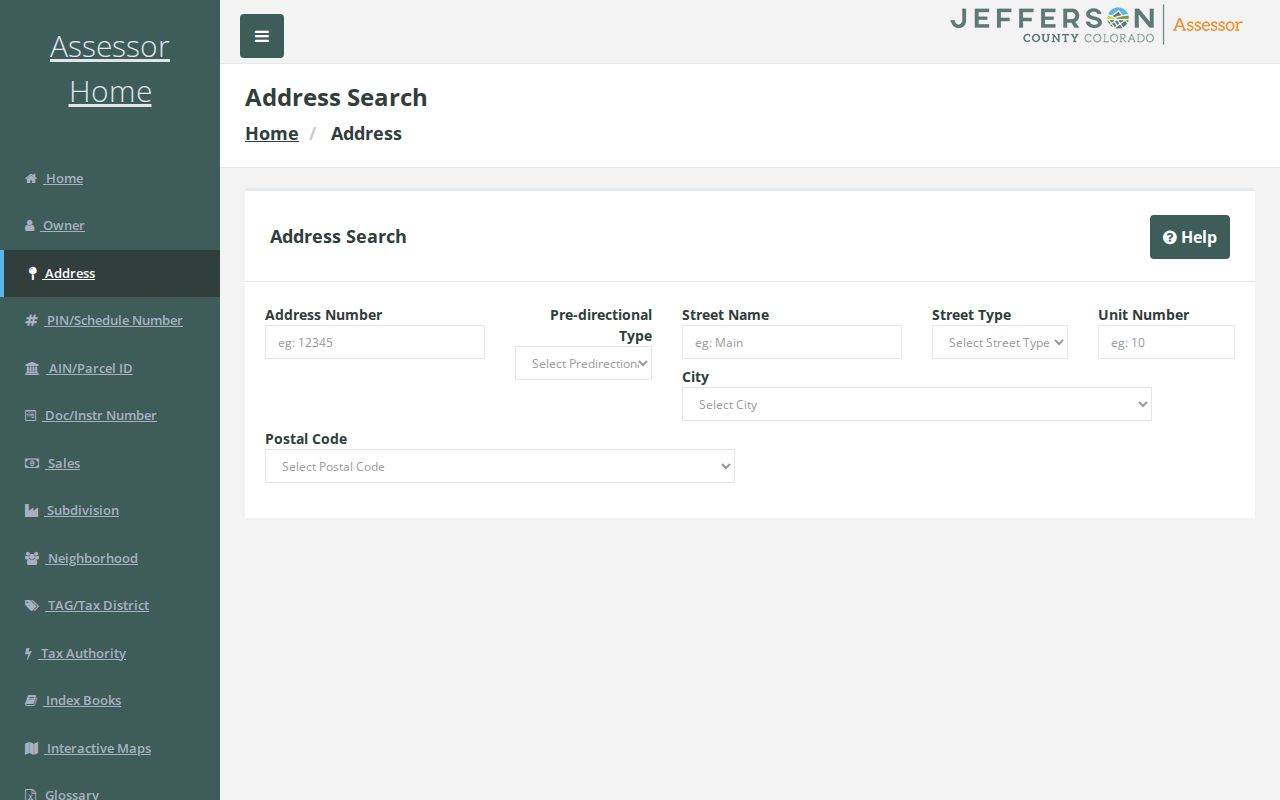
The captured assessor form makes direction, street type, unit, city, and postal code visible before a street-by-street result is trusted.
Arvada Street Records by Address
Address-keyed records answer different questions. The assessor identifies the current parcel card. The Jefferson County Treasurer search adds tax authority, levy, payment, and delinquency detail. jMap shows geometry and public layers. The recorder holds instruments. eTRAKiT adds project and permit chronology. A historical directory or newspaper may show a listed subscriber or an address notice from an earlier period.
| Record set | Keeper | What it shows | Access |
|---|---|---|---|
| Assessor parcel card | Jefferson County Assessor | Owner, situs and mailing fields, PIN/AIN, legal description, value, sales, improvements | Free public portal; current index |
| Tax account | Jefferson County Treasurer | Tax year, authorities, levy, payment, and delinquency detail | Free public portal; current data |
| GIS parcel | Jefferson County GIS | Geometry, adjacent parcels, boundary, zoning, flood, districts, aerials | Free jMap and ASPIN |
| Recorded deed or index | Jefferson County Clerk and Recorder | Grantor, grantee, instrument, legal description, date, image or copy path | Free index; image and copy rules |
| Permit or project | City of Arvada eTRAKiT | Site address, applicant, contractor, work, status, inspections, attachments | Free search; some attachments need an account |
| Voter match | Colorado SOS and Jefferson Elections | One registration match and limited public fields | Individual lookup or controlled request |
| Historical directory | Libraries, LOC, and archives | Earlier listed subscribers, occupants, businesses, notices | Digitized scans, microfilm, or reference request |
The parcel number or legal description is the bridge. A tax account is not a complete owner history, a permit contact is not a resident, and a historical directory line is printed evidence that needs a date and source label. When the address appears in Adams County, redirect the parcel search before treating an empty Jefferson result as a missing record.
Arvada Address Labels Matter
Three address terms should stay separate in any Arvada address reference. A situs or property address is where the parcel or improvement is located. A mailing address is where tax or assessment correspondence is sent. A legal description identifies the land through a subdivision, lot, block, tract, section, township, range, or another deed description.
- Parcel
- A mapped unit of land tied to a PIN or AIN in the county property system. It is a land record, not a list of every person present.
- Situs address
- The physical location label attached to the parcel or improvement. It is the address used to locate the property on a map.
- Plat
- A recorded map that can show lots, blocks, streets, easements, and subdivision structure. It helps test whether an address label matches the land record.
- Criss-cross directory
- A reverse-style directory organized around an address or telephone number rather than only a person’s name. No exact Arvada run was verified.
The City Hall assessor sample shows why this matters: its situs ZIP is 80004, while the displayed Arvada mailing ZIP is 80002. A mailing address can belong to an agent, another property, or a post-office box. It is a clue about correspondence, not proof that the owner lives at the situs.
Note: A deed’s legal description can remain useful after a street label changes, while a printed directory may preserve only the address wording used in its publication year.
Find an Arvada Parcel in jMap
Jefferson County jMap supports several ways to reach the same parcel. Address Locator accepts an address and can return up to six suggestions and 50 results. PIN and AIN searches use fuzzy matching, while owner-name and street-intersection searches provide other routes when an address is incomplete.
| Search mode | Field or type | Options and result behavior |
|---|---|---|
| Address Locator | Address text | Optional; placeholder 100 Jefferson County Pkwy; up to 6 suggestions and 50 results |
| AIN/PIN | PIN text | Placeholder 40-023-00-012; fuzzy matching; up to 6 suggestions and results |
| PIN/Schedule | AUMENTUM_PIN text | Placeholder 300204402; up to 25 suggestions and 6 results |
| Owner’s Name | OWNNAM, OWNNAM2, OWNNAM3 text | Last First format; up to 50 suggestions and 6 results |
| Street Intersection | Intersection text | Placeholder W 10th Ave and Weimer St; up to 6 suggestions and 50 results |
| ArcGIS World Geocoder | Address or place text | General map result |
Turn on parcels, streets, the city and county boundary, zoning or planned development, floodplains, special districts, subdivisions and plats, permits and facilities, public-land survey lines, and aerial photography from 2006 through 2024. LayerList and Legend explain what is visible. PropertyReport, DrawBuffer, Measurement, Attribute Table, Print, and the parcel popup support a reproducible street study.
Click the target polygon, save its PIN or AIN, then click a touching polygon. The map does not promise an automatic adjacent-owner list or a fixed-radius resident export. A buffer is a study aid, not a finding that every nearby person is identified.
Follow Arvada Deeds Backward
Begin with the assessor’s current owner, legal description, and sale-history document number. The Jefferson County Land Records system provides the current recorder route, including real-estate search, marriage search, document images, and account or basket functions. Its public images are unofficial. Use the Clerk and Recorder records page for office instructions, then use the counter or copy form when a certified record is needed.
Search the document number when one is available. Read the grantor, the seller or transferring party, and the grantee, the buyer or receiving party. Record the date, reception number, instrument type, consideration, and legal description. To move back one transfer, search the prior seller as a grantee, then compare the legal description rather than assuming the street number stayed the same.
The current recorder interface and its legacy index are both useful. The county’s February 2025 expansion added 600,000 records and made searchable real-estate and related records reach back to 1970. Separately, the county describes scanned real-estate images from 1859 forward. Those statements describe different access layers.
The current Aumentum recorder screen shows the public search route and the distinction between public searching and account or basket functions. The county document-copy order form supplies the paper and certification path.
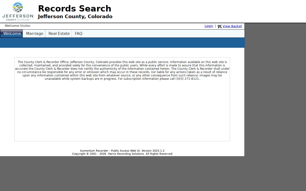
Use the recorder result as an index lead. A document image, certified copy, or older book may require a separate counter or order step.
Arvada Recorder Names and Instruments
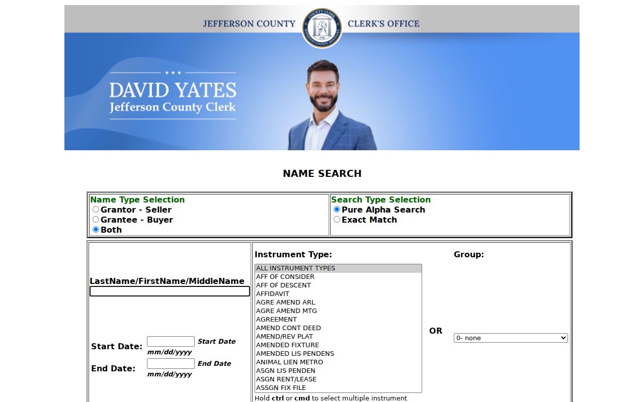
The legacy Jefferson deed name search exposes the mechanics more plainly than the newer landing screen. Choose Grantor-Seller, Grantee-Buyer, or Both. Use Pure Alpha Search for a broad first pass, then Exact Match when spelling, punctuation, or a middle name is known. Add a start and end date, an instrument type, and a report grouping when the first result set is too broad.
Instrument choices include deed, mortgage, lien release, easement, plat, full-scale plat, lis pendens, judgment lien, tax lien, power of attorney, will, and correction or release variants. A name search can return many rows, so add the subdivision, lot or block, PIN or AIN, legal description, and date. The recorder may show 500 or fewer rows first with a full-count option; do not treat the first screen as the complete chain.
The captured legacy form shows the grantor and grantee choices, exact or pure-alpha modes, date fields, instrument filter, and grouping controls.
For copies, the county’s document order route records party names, recording date, reception number, regular or certified choice, delivery address, phone, and email. Digital copies are free; the form states paper copies are $0.25 per page, plats $2 per page, and certification $1 per document or plat. Certified copies are paper-only on that form.
Note: Exact names help the recorder search, but legal descriptions and reception numbers decide whether two instruments belong to the same parcel.
Arvada Permit History by Address
Arvada eTRAKiT adds a dated project layer to by-address research. Search results can connect a site address with a permit number, subdivision, application and approval dates, type and subtype, status, description, job value, certificate-of-occupancy date, and contractor. A detail record can include Site Info, Contacts, Fees, Inspections, Chronology, Conditions, and Reviews.
Use a permit as evidence of work or a project, not as an automatic resident record. An applicant, contractor, contact, or mailing line may be tied to the job rather than the household. Attachments, applications, fees, and inspections can require an account or a separate request. Archived plans should move through the city records route or a written CORA request when the online result is not enough; criminal-justice material follows the CCJRA route.
- Search the site address first, then test project and parcel routes if the address is newly assigned.
- Save the permit or project number, dates, status, description, and contact role with the source date.
- Check the PREH13 record when a permit appears to predate 2013; the portal gives a historical caveat rather than a promise that every older file is online.
- Use Arvada’s records and requests page for city records, police or code paths, MuniDocs, and the public-request route.
The permit trail is strongest when its site address agrees with the assessor parcel and jMap geometry. A mismatch may reflect a project address, a boundary issue, or an older label that needs a deed or plat check.
Arvada Voter Search Is Individual
Colorado’s Find My Registration form asks for First, Last, ZIP, and Birthday. The page advises trying a prior ZIP after a move and contacting the county clerk when a match fails. A confidential or under-18 record may not locate. This is a one-person registration match, not a public street roll.
Colorado’s public voter record can include full name, residence address, party affiliation and date, phone if supplied, gender identity if supplied, birth year, and prior-election participation. Social Security number, driver-license number, month and day of birth, signature, and email are confidential. The result does not show ballot choices. A full voter-file product is a separate request and fee route through the state or Jefferson County Elections, with confidentiality and eligibility rules.
Use a voter match to confirm one known name against an address clue. Do not infer every registered voter from a ZIP, map, or assessor segment. If the state lookup fails, check spelling, a prior ZIP, county contact, protected-voter status, or the Colorado Address Confidentiality Program rather than filling the gap with a guess.
The 1970 Cutoff in Arvada Records
Jefferson’s 2025 recorder expansion is a useful numbers clue: 600,000 added records and a searchable real-estate history back to 1970. It does not turn every deed image since 1859 into a searchable online name result. Older material shifts to books, film, a counter visit, a copy request, or the Colorado State Archives finding aid.
The archive trail lists Jefferson deed record books from 1861 through 1914, grantor indexes from 1862 through 1902, and grantee indexes from 1861 through 1902. The finding aid also includes court, probate, will, naturalization, and coroner series. Preserve the call number, volume, box, access status, and request date. Some older records are open under archive rules, while closed material needs the permission described by the custodian.
The fallback chain is practical: property card to recorder index to county counter or copy form, then State Archives for the older book or index. The assessor does not provide chain-of-title research, and its sales history or deed link is not the same as a certified instrument.
Arvada’s 1953 Telephone Trail
Arvada’s historical address trail is not limited to deeds. Telephone-directory examples span 1912 through 1953, and the 1953 scan notes that Arvada numbers changed to new HArrison 4 numbers. That is a telephone exchange change, not evidence of a street renumbering. A name search that fails because an old number looks unfamiliar should keep the printed street and locality in view.
The Arvada Enterprise adds another local layer. The library resource listing describes a 1903 to 1970 run, while the first-era Library of Congress issue and History Colorado microfilm begin with 1908 material. The difference is about title and issue availability. The Colorado Directories Index helps identify a municipality, county, and year before requesting a volume. Newspapers can supply notices, moves, sales, obituaries, and local context, but OCR text should be checked against the page image.
A regular directory runs name to address. A reverse or criss-cross directory would run address to listed occupant, yet the official research did not verify an exact Arvada reverse volume. Ask a local library reference desk or local historical society archive for publisher and year before treating a volume as reverse-capable. The historical collections and how to read them belong with the Arvada city directory work, while modern parcel records stay address-keyed here.
When Arvada and Jefferson Diverge
Arvada extends into Adams County as well as Jefferson County. A postal Arvada label does not decide which assessor, recorder, treasurer, GIS system, or court holds the record. Start with Jefferson County Address Lookup, which asks for a house number and street selection, then reports municipal status, officials, map, parcel, and tax links. Check the City of Arvada maps and property page for city-limit context, and redirect an Adams-side parcel to the proper county system.
Postal geography adds another layer. ZIP fields identify mail delivery and can cross a legal line. The assessor’s ZIP dropdown is a search constraint, not a boundary declaration. Keep the postal label, situs, mailing address, legal description, PIN or AIN, and municipal status in separate notes. An empty Jefferson result may be a jurisdiction clue rather than proof that no record exists.
Note: The 6809 State Highway 93 water-treatment acquisition shows why an older deed or permit needs a dated boundary check when annexation or rezone materials change the record route.
Arvada Street Directory Limits
A street record can connect public parcel, deed, map, permit, voter, and historical entries. It cannot identify every person present at a property. Household members who do not appear in a public filing, utility and delivery customers, unlisted subscribers, protected voters, ACP participants, juveniles, sealed court parties, and confidential vital-record subjects are outside a public street index.
The same caution applies to a mailing address, permit contact, owner name, or old newspaper line. Each is a dated record clue with a custodian and purpose. Verify an important fact with the office that holds the record, and do not copy protected fields from a voter file or try to reconstruct a protected address through parcel maps.
Lawful use. Arvada street and address records support personal, lawful research, family history, property curiosity, and civic review. Do not use a name or address to stalk, harass, intimidate, or harm anyone.