
Arvada Past Residents: Era Sources
Past occupants of an Arvada address appear in layers. The assessor identifies the current parcel and sale-history clue, the recorder carries instruments, and older books move the search into archives. Directories and newspapers can place a name at a date, while census schedules describe a historical household. Permits date work at the site, not every person who lived there.
The coverage map keeps those questions separate. It also shows when a live portal stops being the right tool. “1859-forward images” and “searchable back to 1970” describe different recorder access claims, and the reverse-directory row remains a research question rather than a verified collection.
| Source | Years It Covers | Where Held | What It Shows |
|---|---|---|---|
| Jefferson deed index and images | Searchable expansion to 1970; images stated from 1859 | Land Records and Clerk counter | Grantors, grantees, instruments, liens, plats, legal descriptions |
| Jefferson deed books and indexes | Deed books 1861-1914; grantor 1862-1902; grantee 1861-1902 | Colorado State Archives finding aid and historical books | Earlier buyers, sellers, deeds, and property identity |
| Arvada Enterprise | 1903-1970 listing; 1908-1970 microfilm | JCPL, History Colorado, LOC/CHNC portions | Notices, obituaries, moves, sales, and local context |
| Colorado telephone directories | 1912-1953 examples | Library of Congress and directory index route | Listed subscribers, addresses, businesses, telephone changes |
| Sanborn Arvada maps | 1917, 1922, 1930, 1941 update | LOC, Denver Library inventory, local holdings | Building footprint, use, street and block context |
| Released census schedules | 1910-1950 releases under the 72-year rule | National Archives and approved library databases | Historical household relationships and geography |
| Arvada eTRAKiT permits | Current index; pre-2013 PREH13 caveat | City of Arvada permit portal | Site work, contacts, inspections, chronology, and attachments |
| Arvada Historical Society | Date-specific local holdings | McIlvoy House and museum | Photos, oral histories, artifacts, and building context |
Start with the current parcel for a recent transfer. Move to the recorder for ownership, then use newspapers, directories, Sanborn sheets, and census years for household clues. At the oldest reachable date, use the State Archives finding aid and the recorder counter rather than assuming that a modern search box contains every earlier image.
Arvada Records Beyond 1970
The February 18, 2025 Jefferson recorder expansion added 600,000 records and made real-estate searches reach back to 1970. The county separately says scanned images are available from 1859 forward. Keep those claims separate: an index cutoff is not an image cutoff, and an image statement does not promise that every older name is searchable online.
Use Jefferson Land Records or its legacy grantor-grantee form. Try Grantor-Seller, Grantee-Buyer, or Both; use Pure Alpha before Exact Match; add dates and instrument type; and vary spelling. Cookies and JavaScript may be required, and an image may require a copy or purchase step.
For earlier books, use the Colorado State Archives finding aid: Jefferson deed books run 1861-1914, grantor indexes 1862-1902, and grantee indexes 1861-1902. The Clerk and Recorder counter is at 100 Jefferson County Parkway, Suite 2560, Golden, CO 80419, Monday-Thursday 7:30-5, phone 303-271-8121. The copy order form supports regular or certified requests by date, names, reception number, and party fields. Digital copies are free; paper copies are $0.25 per page, plats $2 per page, and certification $1 per document or plat. Certified copies are paper-only.
Archives material is requested by call number; film series may be available at the office, some items need retrieval from Simla, and closed items require permission.
Access boundary. The exact fallback is the recorder counter or copy form, then the State Archives series and call-number process. Older material may require retrieval, permission, or a separate visit.
Arvada Previous Residents at the Parcel
The current parcel card anchors a backward search. Use the Jefferson County Property Records Search to save the owner, Property Address, Mailing Address, PIN, AIN, legal description, and sale-history document. Situs marks the parcel; mailing marks tax correspondence. Neither alone proves who lived there. Most Arvada parcel work follows Jefferson systems, but the city also reaches Adams County, so check the county before treating a null result as no record.
Save the fields before opening an older deed. A legal description can preserve a lot, tract, section, or subdivision when a street label changes. The assessor does not provide chain-of-title research or resolve boundaries, easements, or liens; use recorded instruments, plats, or a surveyor.
| Property Address | The situs address where the parcel or improvement is located |
|---|---|
| Mailing Address | The tax correspondence destination, which can differ from the situs |
| PIN and AIN | County parcel identifiers that help bridge the assessor, map, tax, and deed searches |
| Legal description | Subdivision, lot, block, tract, or section language used to test continuity |
| Sale-history document | A lead to the recorded instrument, not a substitute for the deed image |
Save both address forms. A mailing address may be another location, a care-of line, or a post-office box. A tax account, permit contact, or current owner is a lead, not a complete occupancy history.
Sanborn Maps for Arvada House History
Sanborn fire-insurance maps supply building context when the name trail is thin. The Library of Congress Sanborn guide explains that the sheets can show building size, shape, material, use, streets, house or block numbers, water mains, and fire hydrants. They do not name every household.
The official Colorado inventory identifies Arvada editions for 1917, 1922, 1930, and a 1930 base map updated in 1941. The 1917 LOC item is a two-sheet Arvada map; Denver Library's fire-insurance inventory also points to local holdings at the Historical Society and CU-Boulder. Match the map sheet and edition to the block, then compare the footprint and street labels with the parcel's legal description.
Sanborn evidence bridges a deed, directory line, and building story. A footprint can show a structure or use by an edition date, but cannot establish a named occupant. Keep the map date, sheet number, and source institution beside the address note. Review the Colorado fire-insurance map inventory when an older Arvada building needs a sheet-level source.
Trace Arvada Past Residents Through Deeds
A deed chain follows transfers, not a guaranteed list of people who lived at the property. Begin with the assessor result, then use the sale-history document number or legal description to locate the instrument. Read the grantor, grantee, date, reception number, instrument type, and legal description.
- Save the current owner, PIN, AIN, situs and mailing addresses, legal description, and sale-history document.
- Find the purchase instrument in Jefferson's recorder index by document number or party name.
- Read the seller as grantor and the buyer as grantee, then search the seller as an earlier grantee.
- Repeat backward with a date range, instrument type, subdivision, lot or block, and exact legal description.
- Leave the online layer at its verified cutoff and request the older book, index, or certified copy through the counter or archive route.
- Grantor / grantee
- The grantor transfers or releases an interest; the grantee receives it. A deed may list more parties and roles.
- Chain of title
- The linked sequence of recorded transfers and related instruments for one parcel.
- Legal description
- The formal lot, block, tract, or section identity used to test whether two records describe the same land.
Exact spelling matters. Use Pure Alpha first, then Exact Match, party role, dates, and categories such as DEED, PLAT, EASEMENT, LIEN RELEASE, or correction variants. When an address fails, give more weight to the legal description and parcel identifiers than to a modernized street label.
Arvada Previous Residents in Permit Records
Permit records add a dated building trail to an Arvada address-history search. The city eTRAKiT permit form accepts an address, permit number, subdivision, applied or issued dates, permit type and subtype, status, description, certificate-of-occupancy date, and contractor name. A result can open Site Info, Contacts, Fees, Inspections, Chronology, Conditions, and Reviews.
The public search is generally free, but applications and attachments may require an account. Older work has a documented pre-2013 caveat: permits may be attached to a PREH13 record. Archived plans use a city open-record request rather than the live permit index. A permit applicant or contractor contact shows a project connection, not proof that the person lived at the address. Use the record date, site address, project number, and attachment status together.
Open the Arvada eTRAKiT permit search to inspect the address and date fields used for the public index.
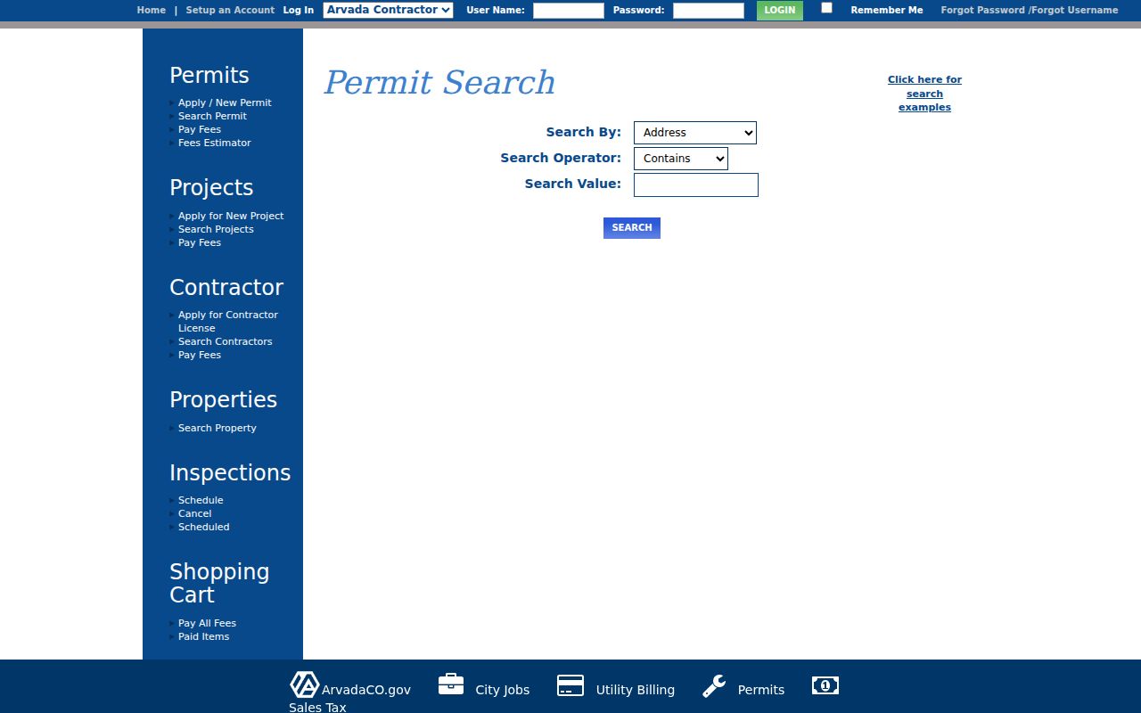
The eTRAKiT controls make a renovation, inspection, or address notice a dated site clue while preserving the distinction between a project record and a household record.
Arvada Historical Society and Past Households
The Arvada Historical Society is the local fallback when a house history depends on photographs, oral histories, artifacts, or building context that never entered a searchable government portal. Its Marcetta Rhoads Lutz Archives are at the McIlvoy House, 7307 Grandview Avenue. The society was founded in 1972 by Lois Lindstrom and also holds museum material connected to the Arvada Flour Mill and Belgin Cemetery.
The Historical Society home route describes archives, museum work, oral history, and local landmarks. Call 303-431-1261 before using the visit information; the posted archive and museum window is Friday-Saturday, 11-3, with call-ahead advice. No complete household index is promised, so ask a focused question about a building, family, business, photograph, or neighborhood.
Check the Arvada Historical Society archive route before planning a house-history visit.
The society can connect a name in a directory or deed to a place, but an oral history or museum label remains a source to cite and assess, not a complete resident roll.
HArrison 4 and Arvada Address Continuity
Address continuity is a common trap in an Arvada address-history search. The fall 1953 Colorado telephone directory says Arvada numbers changed to new HArrison 4 numbers. That is an exchange change, not a verified street renumbering; no citywide Arvada renumbering history was located.
An eTRAKiT notice for project DA2020-0097 identifies 7295 W 56th Ave as a new project address, not a citywide date. Bridge a mismatch with direction, street type, subdivision, lot or block, PIN, AIN, GIS parcel, legal description, and dated newspapers. Jefferson Address Lookup and Arvada maps and property search help check current labels.
Note: HArrison 4 can explain a broken telephone search, but it should never be used as evidence of a street readdressing program.
Match Past Arvada Residents to Census Years
Owners are only one layer of previous residents. A directory line can identify a listed subscriber or household lead, while a census adds historical relationships and geography. The Arvada city directory collections supply title and year details, but a printed name is not automatic proof of occupancy.
Pair a directory year with the nearest census, then use a local newspaper to test the gap. The 1910, 1920, 1930, 1940, and 1950 schedules are checkpoints under the 72-year rule. Census geography can shift, so preserve the enumeration district and page image.
The Arvada Library route supplies newspaper microfilm and reference help, but the main branch closed January 7, 2026 for redesign. The redesign notice identifies the Balsam Temporary Library and a spring 2027 reopening estimate. Call 303-235-5275, then search the free Colorado Historic Newspapers Collection when its title coverage fits the date.
- Write down the address exactly as printed in the directory, including direction and street abbreviation.
- Match that date to the closest 1910-1950 census release and record the household names and enumeration district.
- Search the Arvada Enterprise, Arvada Sun, or later local title for an obituary, move, sale notice, or local event.
- Use probate, wills, or a personal-representative transfer as a lead, then confirm the property instrument in the recorder records.
- Label each conclusion as owner, listed subscriber, household member, permit contact, or printed local reference.
- Criss-cross directory
- An address-first directory that can return a listed name; no exact Arvada run was verified, so the publisher and year must be checked.
- Enumeration district
- The census area's reporting unit, useful when a street name or boundary makes a household hard to match.
- Household clue
- A dated name, address, relationship, or notice that needs a second source before it becomes a conclusion.
Obituaries and probate can close a date gap, but access is record-specific. The State Archives finding aid identifies Jefferson probate and will series; a newspaper notice remains a lead until a deed or probate instrument confirms the transfer.
Lawful use. Previous-resident research in Arvada is suited to house history, family history, and personal curiosity. Do not use a historical record trail to track, confront, harass, or endanger a living person.
Probate, Alerts, and House-History Limits
Probate and wills can explain a transfer after a death. Use an obituary as a lead, identify the probate or personal-representative file, then compare its legal description with the recorded instrument. The archive finding aid covers Jefferson court, probate, will, and related series, but not every file is open or digitized.
Jefferson County offers a free Recording Notification Service for exact-name deed alerts. An alert is not a court finding or proof of fraud. Verify an unfamiliar instrument with the Clerk and Recorder and use county fraud contacts rather than confronting anyone connected to the record.
Keep the source, date, parcel identity, and uncertainty visible. A deed proves a transfer, a directory shows a listed name, a census describes a historical household, and a permit dates work. None is a complete list of previous residents.